publications
Publications by categories in reversed chronological order are automatically arranged.
2025
- Book
 Smart Buildings and Cities with Remote Sensing and GISShiv Mohan, Navneet Munoth, and Neha Sharma, New York, USA, 2025
This book provides a comprehensive overview of the use of remote sensing and GIS in the design, construction, and management of smart buildings and cities. It covers a wide range of topics including architectural site analysis, land use land cover mapping, and the application of satellite missions and data products for urban planning. The book is aimed at researchers, practitioners, and students in the fields of architecture, urban planning, and remote sensing.
@book{sharma2025smartbuildings, title = {Smart Buildings and Cities with Remote Sensing and GIS}, author = {Mohan, Shiv and Munoth, Navneet and Sharma, Neha}, editors = {Mohan, Shiv and Munoth, Navneet and Sharma, Neha}, publisher = {Taylor and Francis}, geography = {Global}, year = {2025}, volume = {1st}, location = {New York, USA}, isbn = {10-1032586113}, doi = {https://doi.org/10.1201/9781003453321}, altmetrics = {true}, dimensions = {true}, keywords = {Remote Sensing, GIS, Smart Buildings, Smart Cities, Urban Planning, Architectural Site Analysis, Land Use Land Cover Mapping, Satellite Missions, Data Products}, url = {https://www.taylorfrancis.com/books/edit/10.1201/9781003453321/smart-buildings-cities-remote-sensing-gis-shiv-mohan-navneet-munoth-neha-sharma}, blog_show = {true}, } - Book Chapter Introduction to Remote Sensing and GISJenish Patel, Neha Sharma, and Shiv Mohan, New York, USA, 2025
This chapter provides an introduction to the principles and applications of remote sensing and GIS in the context of smart buildings and cities. It discusses the fundamental concepts, technologies, and methodologies used in remote sensing and GIS, highlighting their significance in urban planning, environmental monitoring, and disaster management. The chapter sets the stage for the subsequent discussions in the book.
@bookchapter{sharma2025introRS, title = {Introduction to Remote Sensing and GIS}, author = {Patel, Jenish and Sharma, Neha and Mohan, Shiv}, booktitle = {Smart Buildings and Cities with Remote Sensing and GIS}, publisher = {Taylor and Francis}, year = {2025}, volume = {1st}, location = {New York, USA}, isbn = {10-1032586113}, altmetrics = {true}, dimensions = {true}, dimensions_show = {true}, keywords = {Remote Sensing, GIS, Smart Buildings, Smart Cities, Urban Planning, Environmental Monitoring, Disaster Management}, doi = {https://doi.org/10.1201/9781003453321}, url = {https://www.taylorfrancis.com/chapters/edit/10.1201/9781003453321-2/introduction-remote-sensing-gis-jenish-patel-neha-sharma-shiv-mohan?context=ubx&refId=d523735d-ed5f-4ff3-aa58-12bed0f649df} } - Book Chapter Smart Architectural Site Analysis using Remote Sensing and GISDevansh Khare, Neha Sharma, and Navneet Munoth, New York, USA, 2025
This chapter explores the application of remote sensing and GIS technologies in architectural site analysis. It discusses various methodologies for analyzing site conditions, including topography, land use, and environmental factors, to inform architectural design and urban planning. The chapter emphasizes the importance of integrating remote sensing data with GIS for effective site analysis in smart building projects.
@bookchapter{sharma2025siteanalysis, title = {Smart Architectural Site Analysis using Remote Sensing and GIS}, author = {Khare, Devansh and Sharma, Neha and Munoth, Navneet}, booktitle = {Smart Buildings and Cities with Remote Sensing and GIS}, publisher = {Taylor and Francis}, year = {2025}, volume = {1st}, location = {New York, USA}, authors_show = {true}, dimensions = {true}, dimensions_show = {true}, keywords = {Architectural Site Analysis, Remote Sensing, GIS, Smart Buildings, Urban Planning, Topography, Land Use, Environmental Factors}, doi = {https://doi.org/10.1201/9781003453321}, altmetrics = {true}, isbn = {10-1032586113}, url = {https://www.taylorfrancis.com/chapters/edit/10.1201/9781003453321-6/smart-architectural-site-analysis-remote-sensing-gis-devansh-khare-neha-sharma-navneet-munoth?context=ubx&refId=c49d00b6-e727-4dac-9a11-7e014957d3e4} } - Book Chapter Land Use Land Cover Mapping of San Diego Using AVIRIS Hyperspectral ImageryNeha Sharma and Piyush S. Girgaonkar, New York, USA, 2025
This chapter presents a case study on land use and land cover mapping of San Diego using AVIRIS hyperspectral imagery. It discusses the methodologies employed for data acquisition, processing, and analysis, highlighting the significance of hyperspectral data in urban planning and environmental monitoring. The findings contribute to a better understanding of land use patterns and their implications for smart city development.
@bookchapter{sharma2025landuse, title = {Land Use Land Cover Mapping of San Diego Using AVIRIS Hyperspectral Imagery}, author = {Sharma, Neha and Girgaonkar, Piyush S.}, booktitle = {Smart Buildings and Cities with Remote Sensing and GIS}, publisher = {Taylor and Francis}, year = {2025}, volume = {1st}, location = {New York, USA}, dimensions = {true}, dimensions_show = {true}, keywords = {Land Use, Land Cover Mapping, AVIRIS, Hyperspectral Imagery, San Diego, Urban Planning, Environmental Monitoring}, doi = {https://doi.org/10.1201/9781003453321}, altmetrics = {true}, isbn = {10-1032586113}, url = {https://www.taylorfrancis.com/chapters/edit/10.1201/9781003453321-18/land-use-land-cover-mapping-san-diego-using-aviris-hyperspectral-imagery-neha-sharma-piyush-girgaonkar?context=ubx&refId=f944dd67-446e-4ae4-81cb-1b4d51850c8f} } - Book Chapter Satellite Missions and Data Products for Architectural and Urban Planning ApplicationsNeha Sharma, Anandababu Devendiran, Divyeshkumar Rana, and 1 more author, New York, USA, 2025
This chapter reviews various satellite missions and data products that are relevant for architectural and urban planning applications. It discusses the capabilities of different satellite systems, the types of data they provide, and their potential applications in smart building design and urban development. The chapter emphasizes the importance of integrating satellite data with GIS for effective planning and decision-making.
@bookchapter{sharma2025dataproducts,
  title = {Satellite Missions and Data Products for Architectural and Urban Planning Applications},
  author = {Sharma, Neha and Devendiran, Anandababu and Rana, Divyeshkumar and Bandla, Kranthi Kiran},
  booktitle = {Smart Buildings and Cities with Remote Sensing and GIS},
  publisher = {Taylor and Francis},
  year = {2025},
  volume = {1st},
  location = {New York, USA},
  dimensions = {true},
  keywords = {Satellite Missions, Data Products, Architectural Planning, Urban Planning, Remote Sensing, GIS, Smart Buildings, Smart Cities},
  doi = {https://doi.org/10.1201/9781003453321},
  altmetrics = {true},
  url = {https://www.taylorfrancis.com/chapters/edit/10.1201/9781003453321-3/satellites-data-products-smart-buildings-cities-neha-sharma-anandababu-devendiran-divyeshkumar-rana-kranthi-kiran-bandla?context=ubx&refId=5e994abb-430c-431c-bd0c-b8f2274e45e1}
}
2024
- Conf. Paper
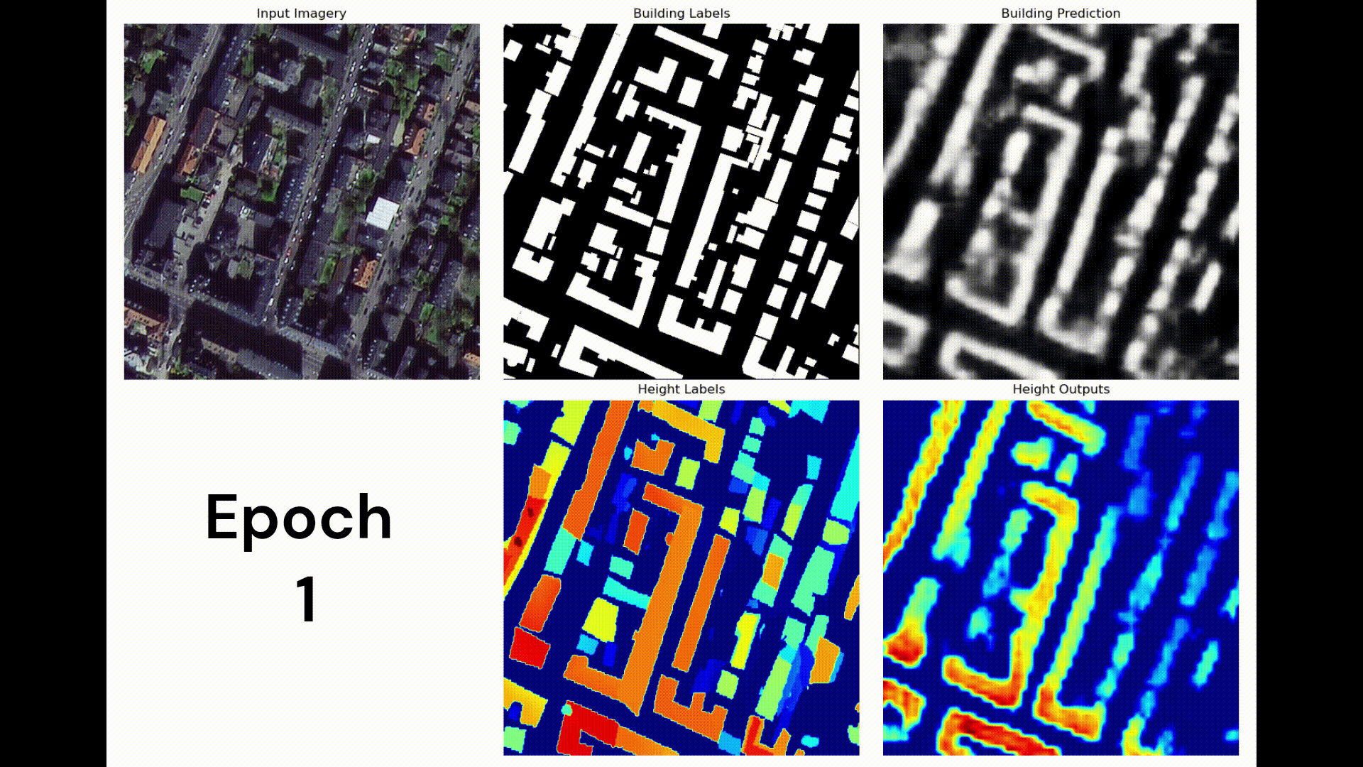 Fine-Grained Roof Type Classification & Multimodal Multitasking Building Detection & Height Estimation Using High Resolution Satellite ImageryNeha Sharma, Sultanova Nailya, Jamila Mustafina, and 1 more author, Malaysia, 2024
This paper presents a novel approach for fine-grained roof type classification and building detection using high-resolution satellite imagery. The proposed method utilizes multimodal multitasking techniques to enhance the accuracy of building detection and height estimation. The results demonstrate significant improvements in classification performance, providing valuable insights for urban planning and development.
@paper{sharma2024roofclassification,
  title = {Fine-Grained Roof Type Classification \& Multimodal Multitasking Building Detection \& Height Estimation Using High Resolution Satellite Imagery},
  author = {Sharma, Neha and Nailya, Sultanova and Mustafina, Jamila and Ismail, Noor Lees},
  authors_show = {true},
  editors = {},
  publisher = {Springer, Singapore},
  booktitle = {International Conference on Data Science and Emerging Technologies (DaSET 2024)},
  year = {2024},
  organization = {UNITAR International University, LJMU, DOSM Malaysia, KLMUC},
  isbn = {978-981-96-7748-1},
  url = {https://link.springer.com/book/9789819677481#overview},
  geography = {Global},
  keywords = {Roof Type Classification, Building Detection, Height Estimation, High Resolution Satellite Imagery, Multimodal Multitasking, Urban Planning},
  location = {Malaysia},
  dimensions = {true},
}
2021
- Book Chapter
 GIS-Based Air Quality Index Spatial Model for Indian CitiesNavneet Munoth and Neha Sharma2021
Purpose—Generation of ‘Spatial and Gridded Air Quality Index Model’ using GIS to compute the AQI using the known ground data for the locations where there are no sensors at a selected grid size. The main objectives of the model are to integrate observations, to predict the unknown values and to make provision for future development without compromising with quality.
@inbook{sharma2021aqi,
  title = {GIS-Based Air Quality Index Spatial Model for Indian Cities},
  author = {Munoth, Navneet and Sharma, Neha},
  booktitle = {Challenges and Solutions for Sustainable Smart City Development},
  publisher = {Springer International Publishing},
  address = {Cham},
  year = {2021},
  isbn = {978-3-030-70183-3},
  pages = {125--167},
  dimensions = {true},
  keywords = {Air Quality Index, GIS, Remote Sensing, Urban Planning, Environmental Management, India},
  doi = {10.1007/978-3-030-70183-3_6},
  altmetrics = {true},
  url = {https://doi.org/10.1007/978-3-030-70183-3_6}
}
2020
- Symposium Paper
 Dramatic & Conspicuous Impact of National Lockdown 2020 on Air Pollution Levels of Ahmedabad DistrictNeha Sharma, Darshana Rawal, Dr. Bindi Dave, and 3 more authors2020
Air is very significant for all types of life in the biosphere. As humans are the prime factor which affects the environment and also adversely gets affected by its consequences. In the current global scenario, air pollution is now becoming a severe problem around the entire planet that has given rise to climatic changes. However, this issue is more acute in developing economies like India where there is a late and fast pace of industrialism with an overweight population, enhanced anthropogenic activities, economic development, and growing energy demands. The rising pollution level in the atmosphere has become a stronger insulator, prohibiting heat from slipping away from earth, back into space and contributing to an increase in overall average temperatures globally. Air pollution renders us ill — it leads to respiratory issues and spreads cancer — and it impacts plants, wildlife and the habitats they reside in. In a 2016 report, the WHO indicated that higher levels of PM in the atmosphere caused 30 lakhs of annual and premature deaths worldwide and out of it, nearly 3% of cardiopulmonary and 5% of lung cancer deaths. This is a worrying scenario and alludes to research and remedial action via numerous different safety and environmental protection methods and strategy measures, mainly in urban areas, with many evidences of past health impacts on humans in addition to regional and local environmental consequences. (WHO Urban Air Pollution, n.d.) In a massive nation such as India, the usable in-situ ground-level measurements are inadequate to accurately fully reflect both the quality of air and the dispersion of pollution. Satellite data themselves have an important place in air quality studies but just cannot stand alone as an evaluation system. A holistic approach is needed to account for various sources to field measurements, correlations of satellite v/s field data, air quality modeling, and health consequences of air pollutants on humans to arrive at a comprehensive assessment of air quality and derive policy-relevant recommendations for air pollution control measures. The national total lockdown 2020 which extended from 24th March 2020 to 20th April 2020, and after that with some conditional relaxation has led to cleaner air all over the nation. This study has aimed to observe the changes in the concentration of air pollutants over Ahmedabad District, Sentinel 5P – TROPOMI data has been used of NO2, SO2, O3, and CO which has a spatial resolution of 5.6 x 3.5 km2 and daily temporal resolution. Terra and Aqua satellite data combined product MAIAC has been used to analyze ‘Aerosol Optical Thickness’ (AOT). It has a resolution of 1km2 and a daily temporal resolution. Level 3 satellite data has been acquired from Google Earth Engine using scripting. PM2.5 and PM10 data have been taken of CPCB live monitoring stations of Gujarat and analysed. This paper is an attempt to represent the preliminary results obtained from the analysis of a study on Urban Air Quality Monitoring, funded by SAC under SHRISTI Programme.
@paper{sharma2020lockdownimpact, title = {Dramatic \& Conspicuous Impact of National Lockdown 2020 on Air Pollution Levels of Ahmedabad District}, author = {Sharma, Neha and Rawal, Darshana and Dave, Dr. Bindi and Vyas, Dr. Anjana and Chhabra, Dr. Abha and Pandya, Dr. Mehul}, booktitle = {Proceedings of the National Symposium on Remote Sensing for Environment Monitoring \& Climate Change Assessment}, publisher = {ISRO - Indian Society of Remote Sensing (ISRS) & Indian Society of Geomatics (ISG)}, year = {2020}, dimensions = {true}, keywords = {Air Pollution, WHO, Climatic Changes, Remote Sensing , Air Quality Monitoring, Ahmedabad}, url = {https://isgindia.org/wp-content/uploads/2020/12/ISRSNS2020_Brochure.pdf} } - Magazine Article
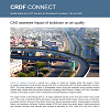 CAG Assesses Impact of Lockdown on Air QualityNeha Sharma2020
The article discusses the impact of the national lockdown in India on air quality, highlighting the significant reduction in air pollution levels across various cities. It emphasizes the role of remote sensing data in monitoring air quality and the importance of continued efforts to maintain improved air quality post-lockdown. The article also suggests that the lockdown provided a unique opportunity to study the effects of reduced human activity on the environment.
@article{sharma2020cag,
  title = {CAG Assesses Impact of Lockdown on Air Quality},
  author = {Sharma, Neha},
  booktitle = {CRDF Connect Magazine},
  publisher = {CEPT Research and Development Foundation (CRDF)},
  year = {2020},
  dimensions = {true},
  keywords = {Air Quality, Lockdown, Remote Sensing, Pollution Reduction, Environmental Monitoring},
  authors_show = {true},
  url = {https://mailchi.mp/ad736c67e458/crdf-connect-5792633?e=e4073af0df}
}
2016
- Journal PaperGreen Building in Hot-Dry Climate - Design ContemplationsNeha Sharma2016
@paper{sharma2016greenbuilding,
  title = {Green Building in Hot-Dry Climate - Design Contemplations},
  author = {Sharma, Neha},
  journal = {Amity University Journal},
  year = {2016},
  dimensions = {true},
  publisher = {Amity University, Madhya Pradesh},
  url = {<URL>},
}